Thursday, September 15, 2011

Bike the Arroyo! Cleanup the Arroyo! This Weekend!

Arroyo Lovers will find lots to do this September weekend!

First, join the 'Stream Team' of the Arroyo Seco Foundation as volunteers celebrate 'Coastal Clean-up Day' with trash removal at the Confluence of the Arroyo Seco and the Los Angeles Rivers, beginning at 9am on Saturday, September 17th. The Confluence is labelled as a 'code red' area because of the high level of trash build-up there, so this is a very important river cleanup! Park in the Home Depot parking lot at Figueroa Street and San Fernando Road. Then walk about 100 yards east on San Fernando to the confluence entrance. Wear long pants, socks, closed toed shoes that can get wet, sunscreen, and a hat. Gloves and trash bags will be provided. This is a zero waste event so bring water in a reusable container.

The fun continues on Sunday, September 18th with the Second 'Tour de Arroyo' bicycle ride from Pasadena to the Cornfields/Los Angeles Historic State Park just north of Downtown Los Angeles. Bicyclists of all ages will rally at 8:30am at Memorial Park in Pasadena for an easy 12-mile 'cruise' on surface streets and the in-channel bicycle path southward, in support and celebration of the upcoming construction of the first phase of the Arroyo Seco Bike Way. Cyclists have the option to join up with other riders at the Cornfields for the Southern California Cyclocross following the ride or group dining in Chinatown or a 'sag wagon' ride back up the Arroyo Seco to Pasadena on the Gold Line. This is a family-friendly event and children are welcome.

For more information and to register for these and other Arroyo Seco fall events, visit http://www.arroyoseco.org/.

Tuesday, September 13, 2011

Los Angeles River Revitalization Corporation Honors Reyes at Kick-Off Event

More than 200 guests gathered on the afternoon of September 11th to help 'kick-off' the newly launched Los Angeles River Revitalization Corporation on the patio of Atwater Crossing near the Los Angeles River.

An independent organization created by the City of Los Angeles two years ago, the LARRC is a non-profit corporation charged with promoting responsible development, redevelopment, and revitalization along the Los Angeles River corridor, in accordance with the Los Angeles River Revitalization Master Plan, according to their website, http://thelariver.com/.

Sunday's event drew quite the 'Who's Who' of Los Angeles 'riverly' people. While guests mingled and noshed, facilitator Ron Milam  got the 'riverly' energy going with his LA River wall mural where everyone was encouraged to draw their 'dream project' for the LA River.

Los Angeles City Council President Eric Garcetti opened the formal festivities by welcoming the enthusiastic crowd, and introduced LARRC's first Executive Director, Omar Brownson, seen here offering his vision for the River, while LARRC Vice-Chairman and first Corporation Chair Harry Chandler looks on.

Omar, who has extensive experience in start-up organizations, spoke of how he's 'come home' to LA to help move LA River revitalization forward.

In the short few months since Omar's hiring in January 2011, LARRC has launched their website, moved to offices at the LA River Center, and hired two additional staff members to work on fund-raising and office operations.

Among the political dignitaries in the crowd were Los Angeles County Supervisor Gloria Molina, Los Angeles City Council Member Tom LeBonge, Los Angeles Public Works Director Paula Daniels, Los Angeles City Planning Commission President Bill Roschen, and LA Planning Commissioner Barbara Romero.

The highlight of the day's event was the presentation by LARRC Board Chairman Daniel Tellalian of the first 'Changing the Course of LA' Award to Los Angeles City Council Member and River Champion Ed Reyes. The award, a beautiful bas relief of a blue heron rising from the River, was a commissioned work created by Los Angeles artist Steve Appleton.

During his remarks, award recipient Reyes spoke passionately about his vision for the LA River, forged by more than a decade of river revitalization advocacy within the City, and spoke how immediate attention on river corridor revitalization would bring much needed new jobs to the City of Los Angeles.

Other 'riverly' leaders spotted in the crowd included: LARRC Board Members Bruce Saito and Daphne Zuniga; LA Mayor's Office Liaison Romel Pascual; LA River Committee Liaison Lupe Vela; US Army Corps of Engineers Planning Chief Josephine Axt; LA Bureau of Engineering's Deborah Weintraub;  LA River Office Director Dr. Carol Armstrong with staffers Larry Hsu and Megan Whalen; CRA's Jason Neville; TreePeople's Andy Lipkis; Landscape Architect Mia Lehrer; Master Gardener Glen Dake; and the Trust for Public Land's Carolyn Ramsay.

Wednesday, September 7, 2011

Community Outreach Set for 'Devil's Gate Reservoir' Sediment Removal Project

The Los Angeles County Department of Public Works has announced that it will hold two public scoping meetings as part of its preparation for an Environmental Impact Report (EIR) relative to its plan for massive sediment removal and management in  'Devil's Gate Reservoir.' Pasadenans more commonly refer to this basin as the Hahamongna Watershed Park.

The EIR preparation, a result of the County Board of Supervisors' vote a few months ago to require County staff to conduct a full EIR on the sediment removal project, rather than move forward with construction under 'emergency' circumstances, requires public scoping meetings, an initial study preparation, a public comment period, and a draft EIR report. As a general rule, this process takes about two years to complete, unless expedited.

The first public scoping meeting will be held on Wednesday, October 5th at 6:30pm at Pasadena's Rose Bowl in the Stadium Locker Room, 1001 Rose Bowl Drive (Park in Lot F, Enter at Gate C). The second scoping meeting will be held on Saturday, October 15th, at 9:00am in the cafeteria at La Canada High School, 4463 Oak Grove Drive, La Canada.

LA County has created a website that discusses both the EIR process and the current Interim Measures Project (IMP) that is removing sediment directly behind Devil's Gate Dam with sediment storage on the former Johnson Field in the Hahamongna. Click this blog's headline to be taken directly to that site.

Friday, September 2, 2011

Tribute to an Arroyo Lover

Pasadena's Arroyo Seco lost a dear Arroyo Lover a couple weeks ago when horse patrol 'guardian' Don Zimmerman died at age 99. Don was a long-time volunteer with the Pasadena Mounted Police Unit.

I did not personally know Don, but all of us who walk, hike, or horseback ride along the Arroyo Seco, especially in the Lower Arroyo Nature Park, knew who Don was.

Three days a week, there he was on his trusty steed, reminding walkers to keep their dogs on leash, admonishing park users not to throw trash on the ground, and cheerily giving directions and offering local color for those visitors who were lost or disoriented.

Even though Don and I only knew each other by the friendly wave that all Arroyo Lovers share, we were kindred spirits. In our own way, we each showed our love for the Arroyo by reminding visitors (and their dogs) all the time to respect our special natural area by picking up trash and doggie doo and staying on trails so that native plant life and endangered species would not be damaged.

While I don't know this for a fact because Don and I never shared our tales, I'm willing to bet that we both got 'yelled at' from time to time by people because we politely asked them to leash their dogs or pick up after their four legged friends. I can't recount all the times that snippy know-it-alls told me that their dogs could do 'whatever they want,' even though I had my Arroyo Seco volunteer shirt on and was very polite. Don had the advantage of being an elder statesman of the Arroyo, sitting above the crowd on the back of Maca, but I'm certain he occasionally got some attitude from these whippersnappers, too.

Of course, Don, I and all Arroyo Lovers only ask other users of the trails to be good stewards so that the Arroyo Seco's beautiful riverine parkland will be here in its natural condition for future generations to enjoy. It's too bad that some of our residents and visitors don't share that respect.

A special memorial service open to all will be held at 11 am on September 17th at the First United Methodist Church, 500 E. Colorado Blvd, Pasadena. If Don Zimmerman ever waved to you on the trails or reminded you to put your dog on a leash, you might want to come by to pay your respects.

Don 'patrolled' the Arroyo Seco on horseback for 25 years. I've only been patrolling for 4 years. I think I still have a long way to go to fill his boots.

Happy Trails, Don.

And if you're out enjoying the Arroyo Seco this holiday weekend, please show some respect for Don by keeping your dog on its leash and bringing trash/doggie doo bags along with you to clean up after yourself.

Tuesday, August 16, 2011

August Happenings on the Los Angeles River & The Arroyo Seco

It's hard to believe it's August already with the summer quickly moving along. Here's some of the latest goings on with the Los Angeles River and the Arroyo Seco.

1. The big exciting news is that the US Army Corps of Engineers has issued permits to allow a 'Pilot Non-Motorized Boating Program' to take place on the Los Angeles River in the Sepulveda Basin area over a 6-week weekend test period.

Dignitaries from far and wide attended the August 8th 'kick-off' event, including USACE Colonel Mark Toy, LA Conservation Corps Executive Bruce Saito (whose organization is the lead agency for the pilot program), kayak activist George Wolfe, Melanie Winter of The River Project, Miguel Luna from Urban Semillas, and Lupe Vela, LA City Liaison to the Los Angeles River Committee. Political heavyweights included Joe Edminston of the Santa Monica Mountains Conservancy, LA City Councilmember Tony Cardenas (in whose district the pilot program will take place) and LA City Councilmember Ed Reyes, whose vision and commitment over many years to revitalize the LA River was noted.
Once the official festivities ended, it was time to get the boats in the water! While this was a short ceremonial paddle in the LA River, it heralded the beginning of a new era of river access for the public.

The pilot program sold out within minutes of opening for reservations, so it won't be possible to participate in this month's paddling events if you are not already one of the lucky persons with reservations. Organizers are hopeful, though, that this initial pilot program's success will facilitate expanded boating access to the LA River soon.

2. If you are not a fortunate paddler, don't dismay. Friends of the Los Angeles River (http://www.folar.org/) is offering 90-minute docent led walks along the LA River in the Sepulveda Basin highlighting this historic non-motorized boating program beginning August 21st. Reservations are required - free to FoLAR members - $10 donation for non-members.

3. Feel like getting your hands dirty? River lovers have two opportunities this Saturday, August 20th:

The Arroyo Seco Foundation (http://www.arroyoseco.org/) is hosting a Central Arroyo Stream clean-up from 9:30am to 11:30am to remove trash and invasive species in the naturalized area of the Arroyo Seco just south of the Rose Bowl in Pasadena.  Park at the south end of Brookside Parking Lot I near the Aquatic Center and meet at the picnic tables in the south end of the Rose Bowl Aquatic Center. Wear sturdy shoes, working clothes, a hat, and sunscreen. Tools and trash bags will be provided. It's a fun way to enjoy and help nature at the same time.

Live on the other side of LA? Why not join the Village Gardeners from 9:00am to noon for some native plant landscape maintenance along the LA River in Studio City at the Richard Lillard Outdoor Classroom, 13236 Valleyheart Drive (south side of The River, 1/2 block east of Fulton)? Wear closed toed shoes and bring a hat and sunscreen. Tools and gloves will be provided. Refreshments, too! RVSP to rrabins@villagegardeners.org or 818-667-7605.

4. The Los Angeles River Revitalization Corporation (http://thelariver.com/) has two upcoming events as well: Their Board of Directors holds its quarterly meeting on Wednesday, August 17th, 5:30pm to 7:30pm, in the Mayor's Press Conference Room at Los Angeles City Hall. September 11 from 3:30pm to 5:30pm, marks LARRC's inaugural community event, Let's Talk River, honoring Los Angeles City Councilmember Ed Reyes.

Finally, if you just want to get out and enjoy urban nature this month, check out the recreational opportunities along the Arroyo Seco, including the Arroyo Seco Trail Guide here: http://www.ci.pasadena.ca.us/PublicWorks/arroyo_recreation_and_activities/

Friday, August 5, 2011

Riding Along the Arroyo Seco on the Back of a Horse

Once in awhile, serendipity creates a great adventure.

Such was the case last week when I spotted a friend bathing one of his horses on a weekday afternoon. Surprisingly, we both had finished with work early that day and before I knew it, he said, "Let's go riding!"

For a horse lover like me, I jump at the chance to ride whenever I can, so we took off on our trusted steeds, him on Maya, me on Lobo (seen here) for what I thought would be an hour ride from the Altadena Crest Trail to the Loma Alta Equestrian Arena.

But you can't stop horse people when they are having a great ride on a beautiful summer's afternoon. Before I knew it, I was agreeing to ride all the way down to the Rose Bowl in Pasadena (a four hour round trip ride, I might add)!

And what a great ride it was! Entering the Hahamongna Basin eastside trail from Altadena Drive, we enjoyed a slow quiet ride through one of Pasadena's great urban nature corridors. The birds were singing, the air was fresh from a slight breeze and the Arroyo Seco was still full of water, unusual this late in the summer season. Except for the passing of an occasional walker and photographer, we had the trail all to ourselves.

Soon we were travelling through the Devil's Gate Bridge tunnel down the trail to the Central Arroyo. I especially loved riding this section - so natural and quiet with the unchannelized Arroyo Seco stream to our right, gurgling along.

Civilization in the form of Brookside golfers and Rose Bowl Loop bicyclists and joggers soon appeared as we turned onto Washington Blvd to Parkview towards the westside Arroyo Seco trail heading back northward.

This was my first time on the Central Arroyo Seco westside trail and what a delight! Most of this trail is shadowed by old age oak trees on one side with a bucolic view of Brookside Golf Course on the other. My unflappable horse, who calmly walked down city streets, past bicyclists, cars, and joggers, stopped and perked up his ears each time a golfer teed off and the 'whiff' sound filled the air.

I really loved being on the westside trail which brought us right next to the Arroyo Seco stream north of the golf course. In fact, we had to cross the stream, about ankle deep, to reconnect to the trail back into the Hahamongna and northward home. What fun!

Sir Winston Churchill once said that 'the outside of a horse is good for the inside of a man' (or woman!) and this adage was no more true than while on this ride along the Arroyo Seco.  It's incredible that it's possible to ride (or walk!) streamside in an urbanized area of Southern California....yet feel totally in nature.

I can't wait to continue my horseback riding adventures along the Arroyo Seco and look forward to future trips both northward into the Angeles National Forest and southward into the Lower Arroyo Seco and South Pasadena Nature Parks.

Wednesday, August 3, 2011

Los Angeles River Chosen for New Urban Waters Federal Partnership

The Los Angeles River has been chosen as one of seven river watersheds nationwide to participate in the new pilot program of the Urban Waters Federal Partnership. This pilot program aims to revitalize growing American cities and the natural resources that surround them.

This new national partnership aligns the programmatic goals of the White House's Great Outdoors Initiative and the Partnership for Sustainable Communities to link economic revitalization with environmental sustainability.

Designed to break down federal government agency 'silos,' while promoting collaboration among federal, state, local agencies and non-profit and community-based environmental organizations, the Urban Waters Federal Partnership selected the Los Angeles River Watershed in part because more than 70% of its residents live more than a quarter mile from a park or open space, resulting in a lack of access to such environmental resources as clean air and potable water. The LA River was also cited for its success record in current federal colloboration efforts along the river corridor, especially in working with disadvantaged communities.

The focus of this new partnership is on revitalizing local watershed efforts, including enhancing flood control, improving water quality through green infrastructure, enabling safe public river access, and restoring ecosystems.

Examples of ongoing work where local communities in the Los Angeles River Watershed are engaged in partnerships with federal agencies are the: Station Fire Restoration, Los Angeles River Ecosystem Restoration, South Los Angeles Wetlands Park, Hansen Dam Wetlands/Stormwater Treament/Park Expansion Project, the Elmer Street Neighborhood Retrofit, and Disadvantaged Community Outreach Education Program.

The Partnership's immediate focus is on facilitating more economic development, especially in the Clean Tech Corridor; more recreational river access opportunities; more outdoor education in partnership with the LA Unified School District; and enhanced focus on conservation of the region's scarce water supply.

Spearheaded by leadership from the US Environmental Protection Agency (EPA), participating federal agencies include the US Department of Agriculture (USDA); Department of the Army - Army Corps of Engineers (USACE); US Department of Commerce - Economic Development Administration (EDA); US Department of Commerce - National Oceanic and Atmospheric Administration (NOAA); Corporation for National and Community Service (CNCS); US Department of Health and Human Services - US Centers for Disease Control and Prevention (CDCP); US Department of Health and Human Services - National Institute of Environmental Health Sciences (NIEHS); US Department of Housing and Urban Development (HUD); US Department of the Interior (DOI); and US Department of Transportation (DOT).

The six other American river watersheds selected for this federal pilot program include: Anacostia Watershed, District of Columbia/Maryland; Patapsco Watershed, Baltimore Region, Maryland; Bronx & Harlem River Watersheds, New York; South Platte River, Denver, Colorado; Lake Ponchartrain Area, New Orleans, Louisiana; and the Northwest Indiana Urban Corridor along the Lake Michigan Shoreline.

Monday, August 1, 2011

The Pasadena Open Space & Conservation Element Update Points to a Sustainable Future

While local activists debate sediment removal in the Hahamongna at tonight's City Council meeting, another meeting will be taking place with a Pasadena City-appointed committee of citizens who have quietly been working for the past year and a half on the updating of the Open Space & Conservation Element to the City of Pasadena General Plan.

Under current State law, all California cities must periodically update their general plans, addressing such elements as housing, transportation, and health. The current committee has been working diligently with City staff and community stakeholders to both update the current Open Space & Conservation Element and integrate these general plan elements with the Green Space Element approved by the City in 2007 as well as the City's Green City Action Plan for sustainability (air quality, water quality/conservation and energy/greenhouse gas reductions).

After months of fact-finding, deliberation, community outreach meetings, walkabouts, and review of numerous plans and studies, the draft document for the Open Space & Conservation Element has been completed and will now be circulated to other City Commissions, including the Environmental Advisory Commission and the Recreation and Parks Commission, for review before reaching the Pasadena City Council for final approval.

The 63 page document, which can be accessed by clicking this blog's headline, provides a comprehensive overview of current City natural elements, conservation partners, sustainability issues, and urban nature needs within a framework to guide the City for future open space acquisitions and current open space stewardship. It was particularly gratifying to see in this report the extensive attention placed on the role that open space and conservation plays relative to water conservation and sustainable building practices.

The Open Space & Conservation Element Committee meets tonight at 6:45pm in the Grand Conference Room in the Basement of Pasadena City Hall. The meeting is open to the public and will be a fascinating update on a visionary future for Pasadena's urban nature culture with an eye towards an integrated approach to sustainability.
Enhanced by Zemanta

Thursday, July 14, 2011

Arroyo Lover on the River Road

Is this the La Loma Bridge in Pasadena? Of course not. The natural stream course under the bridge looks nothing like today's concrete channelized Arroyo Seco. But it could look like this in the future if we remain vigilant in restoring our historic Pasadena stream.

I haven't posted here recently because for the past few weeks, the Arroyo Lover has been on the road to her native Ohio and what a treasure trove of watershed restoration and revitalization activity it's been!

The photo above is actually of Mill Creek, a major tributary of the Mahoning (meaning Salt Licks) River, deemed by the USACE as one of America's five most polluted rivers due to a century of steel mill and manufacturing toxin dumping into its waterways.

Fortunately, Mill Creek is relatively pristine, thanks to the leadership of Volney Rogers, who created Mill Creek Park in 1891, the first park district in Ohio. Today, Mill Creek Metroparks manage 4800 acres of riverine parkland (more than double the Arroyo Seco parkland in Pasadena!) full of trails, athletic fields, golf courses, and historical landmarks, like the Lanterman Mill, seen here, one of the first grist mills on the creek which was completely restored in the 1980s. This historic restoration allows visitors to visit one of the finest riverside interpretative sites I've ever seen: you can walk four levels within the mill, including down to the water wheel itself. In addition, the viewing platform next to the falls is so close you can feel the spray! And what a great old wooden dam made of railroad ties, still functional after 100 years. Los Angeles County engineers could take a clue about how to use natural materials on area waterways from this project.

And what fun is a river if you can't play on it? So, one Sunday afternoon, I joined about 15 members of the Trumbull Council Trails Canoe Club (ranging in age from 3 years old to 75!) on a 5 mile 'float' down the Upper Mahoning River (the healthier part). Aside from an occasional railroad trestle or highway bridge overhead, we did not see much evidence of civilization but we did see a lot of nature's beauty: birds, flowers, and trees in full foliage. It was interesting to see how many tree branches were down in the river, creating a sort of 'mogul' run, and how little human trash was in the waterway. The Canoe Club members are the nicest people, too! They virtually let me crash their party, shared a canoe, and gave me a paddle and PFD (personal flotation device) to use. We had lots of water wars, too, with the youngsters in particular trying to spray us old folks with water from their Max Liquidators. But I got revenge when one of the boys accidentally dropped his water gun in the river, which I retrieved, then took aim and fired away!

Next it was off to the Cuyahoga ( meaning crooked) River, once famous for having caught on fire. But what a difference 40 years of restoration makes!

From listening to the Cleveland Orchestra perform at Blossom Music Center within the Cuyahoga Valley National Park to exploring the Upper Cuyahoga river towns of Aurora and Hudson, it was a delight to see the river so healthy.

Finally, it was time for a stop in my old college town, Kent, Ohio, where the city undertook a $5 million dam removal/river restoration project completed about 5 years ago. And look at what a terrific achievement it is - a free flowing river once again supported by a beautiful waterfall, riverwalk, and direct access to the river. Home to the Davey Tree Company, Kent is the original 'Tree City,' making the woodsy river stroll cool and breezy. The day of my visit, a few young fishermen were fly fishing along its shore.

This area of the river is also popular with kayakers and Kent State University students run a canoe livery on weekends based out of Tannery Park. Most exciting of all is Kent's planned natural whitewater park along this section of the river. Kent City Manager Dave Ruller graciously shared with me the conceptual design plan for the whitewater park. Yes, the river only reaches a maximum of 1100 cfs - not Class 3 or Class 4 rapids, but definitely a fast enough flow for some serious water fun.  It's an exciting project that will create a terrific water trail through the middle of this college town. Wouldn't it be great to have something like that on the Los Angeles River, too?

This trip certainly offered a different perspective to my usual work in the Greater Los Angeles area, where water shortage and channelized waterways are the norm. Strategically located at the heart of the top of two major watersheds, the Cuyahoga (which flows north) and the Mahoning (which flows southeast), Northeast Ohio has plenty of water and is one of the few non-water stressed regions in our country. The environmental ethic is very strong here as well, because intuitively the people who live in this region know that trash interferes with the food chain. (Agriculture is still the number one 'industry' in Ohio). Even the former Mayor of Struthers, now Youngstown State University's Urban Studies Professor and Mahoning River Restoration collaborator, lamented his inability while on city council to get the area designated a watershed district!

This eastern navigable rivers visit was definitely a Huck Finn type of adventure with my Ohio river brothers and sisters. What an inspiration for those days when achieving true integrated urban river restoration seems an impossible dream!

Monday, June 20, 2011

California State Water Project Inspection Trip Revealing


Though I have been teaching California Water to Cal Poly/Pomona students for the past three years, I had not had the opportunity to visit the 'Holy Grail' of the California State Water Project until this past week. 

Thanks to an invitation from the Metropolitan Water District of Southern California through Pasadena Board Director Tim Brick, I was invited to join 36 others in a behind the scenes 'inspection tour' of the State Water Project (SWP).

The two day trip was a whirlwind visit to the Oroville Dam, the Feather River Fish Hatchery, the Oroville Dam Visitor Center, the Delta and levees, the Banks Pumping Plant and the Skinner Fish Facility, with a briefing on current Bay-Delta issues at MWD's Sacramento office.

Our inspection group included a dynamic mix of water agency, water contractor, environmental, governmental, and education representatitves, which facilitated lively discussions both on the bus and during group lunch and dinner sessions.

Highlighting our first day was a trek up to Oroville Dam on the mighty Feather River. The photo above was taken from below the Fish Hatchery and gives a pretty panoramic view of the watershed, dam and hatchery, where salmon and steelhead are raised, then released into the River or San Francisco Bay.

The water release from the Dam that day was an amazing 8,000 cubic feet per second (CFS), the fastest June flow on record in the 40+ year history of SWP.

The second day of the trip focused on visits to the southern delta of islands and levees with terrific commentary by Curt Schmatte on the complex environmental issues facing the region.

The State Water Project, initially conceived by State Engineer Edward Hyatt (the Oroville Pumping Station is named after him) in 1931, was approved by the voters for bond funding in the Burns-Porter Act of 1960, with the construction of the first phase completed in 1971. The second authorized phase, the Peripheral Canal was never built, since the bond measure to fund it, Proposition 8, was defeated in 1982.

The largest American publically financed water works project, SWP's main purpose is to provide reliable water supply to 80% of Californians: urban and agricultural users in the Bay Area, Central Valley, and Southern California. The Project is also operated to improve water quality in the Delta, control Feather River flood waters, provide recreation, and enhance fish and wildlife.  The diversion gates at the Skinner Fish Facility (above photo) facilitate capture and relocation of fish downriver to prevent fish predation (death by predator, whether biological or human).

The key focus of this trip was on sustainability issues that will both ensure water reliability and ecological function, particularly relative to fish health. A half century of water pumping has taken its toll on the land along the delta levees, where subsidence has resulted in fields and groundwater storage areas now up to 30 feet below sea level. In addition, extensive pumping has negatively impacted fish spawning, especially the Delta smelt, resulting in court orders limiting pumping to protect fish habitat.

The 'Bay-Delta' portion of SWP covers over 700 miles of open canals and pipelines. The 'Bay' refers to San Francisco Bay while the 'Delta' refers to the confluence of the Sacramento and San Joaquin Rivers. An interesting fact is that the Delta itself is actually inland from the Bay, connected by the Suisun Marsh, where the ocean salt water meets river fresh water.

The MWD briefing included mapping of the Bay-Delta affected areas, an overview of the challenges in meeting water supply due to ecological damage and pumping restrictions, and a discussion of the 2009 water bond act approved by the state legislature scheduled to be placed on the November 2012 ballot seeking voter-approved funding. The site visits, like the one in the photo above of our group taken on the bridge at the Skinner Fish Facility offered dramatic evidence of these challenges.

The size and scope of the SWP in the Bay-Delta area was mind-boggling and our group covered a lot of territory in two short days: Pasadena-Burbank-Sacramento-Oroville-Sacramento-Southern Delta Cross Channel-Twitchell Island-Sherman Island-Franks Tract-Oakland-Burbank-Pasadena.

Clearly, there is still no consensus among water contractors, agricultural users and environmentalists over the properr CALFED solution for the Bay-Delta area. Nonetheless, the tour dramatically showed how vulnerable all Californians are if an 8.1 or greater earthquake strikes the area, which would result in a total collapse of the levee system and significant damage to pumping and diversion infrastructure.

Sunday, June 12, 2011

The Loss Of Open Space No One's Really Talking About...


We seem to be bombarded almost daily with these frightening headlines: State Parks to Close...Irvine's Wild Rivers Water Park to relocate to make way for an apartment complex...LA River projects on hold due to lack of funding.

Yet the most disturbing 'closures' are the places where many of us hold our first memories of childhood exploration in nature: The Summer Camp.

Throughout the country, Girl and Boy Scout Councils, church organizations, private families and civic organizations are doing the once unthinkable: closing their camps and putting the properties up for sale to raise revenue to keep their operations alive. More and more we are seeing large swaths of open space becoming abandoned by long-time property owners and tenants (as is the case of several camps within our National Forest system).

This trend is troubling for a number of reasons:

1. the great likelihood that these parcels will be purchased by those who intend to develop the land
2. the fact that many of these camps have learning-oriented recreational improvements in place that will likely be destroyed
3. the loss of 'one tank trips' to get families into nature during a time of economic turmoil

While this movement is nationwide, the example of one camp: Camp Sugarbush, where I spent much of my childhood as a Girl Scout camper, is illustrative of this sad trend.

Camp Sugarbush embraces almost 200 scenic wooded acres in rural Northeast Ohio and its name connotes the large stand of sugar maple trees growing in the area. This camp is highly improved with a lodge/dining hall, infirmary, heated swimming pool, small canoe lake, archery range, game fields, and an observatory. Overnight camping amenities include cabins, a primitive cabin, covered wagons (yes, you can sleep in them just like the pioneers did!), and perma-tents with cotting and mattresses. The lodge and cabin include flush toilets and hot showers (yay!).  All other units have their own pavilion, latrine, and running water. The camp offers day camping, overnight camping and primitive camping options.

For me, Camp Sugarbush was more than just a place to hang out at during the summer. Here I learned ritual and survival skills that still serve me well today. Among my 'firsts' at Camp Sugarbush: first archery lesson, first primitive camping experience, first canoeing, first campfire singalong, and first leather tanning. I hated the sound of the bugle at 6:30am waking us up and calling us to the flagpole for the morning camp opening ritual but loved making s'mores over the campfire. I hated repelling the nasty mosquitoes buzzing around but loved our hikes in the woods, learning the names of plants and trees, while in search of 'edible' berries. I learned the difference between poison oak and poison ivy. I learned how to watch out for snakes (by the way, this is a skill that applies to human snakes, too). I learned how to catch frogs. I hated latrine duty but learned the connection between human waste and our watershed at a young age. I loved the ride and commaderie on the camp bus and can still smell the hickory smoked campfire air.

A couple months ago, the Girl Scout Council of NE Ohio voted to close Camp Sugarbush and four others, with the plan to sell them to raise funds to keep the organization financially sustainable, while reorganizing camping activities around two 'leadership centers.' But what will the final fate of this and many other camp grounds nationwide mean?

Born of the 'garden movement' at the turn of the 20th Century and nurtured as church groups and youth organizations such as the Boy Scouts, Girl Scouts, Campfire, and 4-H were founded and grew, the nature summer camp gave children and families the opportunity to leave the sooty, dirty industrial city where they lived and camp under the stars in nature.  According to the American Camp Association, summer camps serve over 10 million Americans at 12,000 accredited campsites.

Only 10 million? No wonder these open spaces are quickly becoming endangered species. Despite the cries about nature deficient disorder in our children due to urban upbringing, fewer youth than ever are engaging in overnight camping away from home.

Several factors have led to this decline: the rapid urbanization of America where today more than half the population lives in cities, stressed out two-income and single parent families who are struggling just to financially survive, and computer-video game-virtual reality technology that entertains more and more of our children, just to name a few.

And here's the saddest part:  unless you grew up in a camping family or attended camp as a child, you have probably forgotten how to camp and live outdoors.  Anecdotally, I'm always surprised how, when I take visitors down to the Arroyo Seco in very civilized Pasadena, they quake in their shoes when I mention wild critters in the area, especially snakes.

While nature can be enjoyed just for nature's sake through hiking, bicycling, and horseback riding, natural camp grounds are critical playgrounds for learning skills of survival and skills of teamwork and leadership. Moreover, since most camp grounds are located on a freshwater river or stream, these natural playgrounds are a key source of watershed education, too

Whether it's state parks, public campgrounds or civic/church owned camp sites, we risk losing some of our most precious low impact recreational open space if we cannot develop new models of joint use, cross-organizational collaboration, and revenue enhancement. And where are the land conservancies? While conservancies focus on ranch, farm, and urban interface properties, I've yet to see an organized effort to acquire and conserve these precious camp lands.

This summer, take your loved ones camping before it's too late. Better yet, bring along a friend or two and introduce them to the joy and wonder of living, for at least a brief time, in nature.

Friday, June 3, 2011

Arroyo Property of the Week - Sleek Pasadena Townhome

New to the market, this light and bright 2 bedroom plus den, 3 bath townhome on California Boulevard at Los Robles is priced under $450,000.

Boasting over 1500 square feet of living space, this front north-facing unit has spectacular views of the San Gabriel Mountains.

The spacious living room features hardwood floors, a fireplace, wet bar, and huge balcony for enjoying gorgeous sunsets.

The sleek Euro kitchen features an atrium style breakfast nook and the downstairs 'den' is perfect as a recreation room, office or third bedroom.

The townhome complex features a private community pool, lush landscaping and a huge courtyard with several fountains. HOA dues include earthquake insurance coverage. Yes, the unit includes two parking spaces and they are side by side!

Best of all is the perfect location of this townhome. Situated in the highly desired Madison Heights area of Pasadena, it has a terrific 72 walkability score. Bicyclists will love riding the 12 miles of bike lanes in Pasadena from this home, commutable to the Del Mar Gold Line station, Caltech, South Lake Shopping District, and my beloved Lower Arroyo Seco Nature Park.

This is a must see value in one of Pasadena's finest neighborhoods! Please call me at 323-230-9749 or email me at arroyolover@gmail.com if you'd like to take a look!

Tuesday, May 31, 2011

Where Should the Sediment Go? The Devil's Gate Dam Dilemma

UPDATE 8/2/2011: The Pasadena City Council unanimously approves use of Johnson Field for sediment storage during LA County's interim project to remove sediment buildup behind Devil's Gate Dam.

-------------------------------------

To understand the current dynamics playing out in the Hahamongna about sediment removal behind Devil's Gate Dam, we must look at what got us to this point.

Here's a short recap:

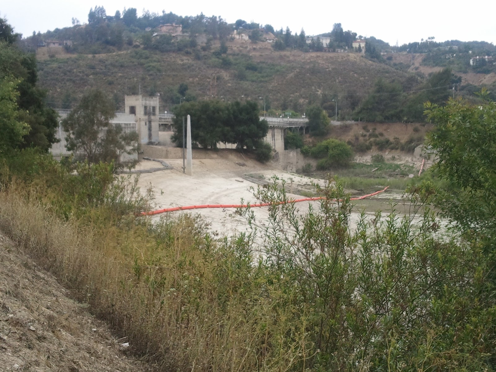
.The 2009 Station Fire wildfire burns almost 70% of the upper Arroyo Seco watershed, depositing over 1,000,000 cubic yards of sediment into the Hahamongna Basin, much of which collects behind Devil's Date Dam
.LA County plans to remove all sediment in the Basin under 'emergency' maintenance procedures which do not require an Environmental Impact Report
.The local environmental community protests and the LA County Board of Supervisors approves a resolution requiring a complete EIR be done before sediment removal occurs, with the exception that County Public Works can remove 25,000 cubic yards this summer directly behind the Dam because of emergency maintenance conditions.
.LA County Dept of Public Works finalizes its interim sediment measures and starts conducting community outreach meetings to review truck transportation routes to haul the sediment out of the Basin for relocation to Scholl Canyon.
.The interim sediment removal plan must be completed by October 15, 2011, when the annual rainy season traditionally begins.

Yet the controversy seems to go on....

Why?

First, while LA County has put together a generally sound interim sediment plan, it has failed in its ability to properly communicate this plan to the public. Case in point: last Thursday night's outreach meeting at La Canada High School to discuss the 'truck haul' plans. What didn't go wrong?  The powerpoint did not work. There were no handouts. A new alternative #4 to keep the sediment in the Basin was announced with little context as to why this option was now being offered. Presenters seemed to be at a loss to directly answer many questions posed by the attendees.

But the enviro community and residents are not blameless here, either. Numerous bloggers, local residents and environmental organizations continue to disseminate skewed information and promote 20th Century style scare tactics online and in whisper campaigns to rally their troops towards either stopping this sediment removal or warning of 'dire' consequences if it occurs. They aren't offering any proactive alternative solutions, either.

So let's look at the facts relevant to public safety. (All these documents are online and available to the public at the dpw.lacounty.gov site.)

If you click on the header to this blog, you will be taken to the  LA County Staff Report to the Board of Supervisors which accurately discusses the issues. Then take a look at the powerpoint for the interim removal plan here:

tp://dpw.lacounty.gov/wrd/removal/DevilGate/CVAC_Interim_Measures_20110525.pdf

When we cut to the chase these facts remain:

1. The sediment directly behind Devil's Gate Dam has reached a level of 1,009 feet
2. This sediment is blocking at least two sluice gates, which are responsible for releasing water through the flood gates.
3. This sediment is also close to clogging the outlet valves at the top of these sluice gates.
4. This sediment, if not removed this summer, will likely clog outlet valves, including tunnel water outlets after the next rainy season.

Clogged sluice gates and tunnel water outlets mean that the Watermaster will be unable to discharge water through the dam.

Here's the unknown: how much precipitation the Arroyo Seco watershed will get this rainy season. It's especially difficult to predict because we are now experiencing chaotic weather patterns, witnessed by Mississippi River flooding, deadly Southern tornados and a West Texas drought and fire storm. As one local example, the experts at NOAA predicted a 'dry' La Nina last year and we got instead one of the wettest seasons in recent years. Should we have another wet rainy season, even more sediment will flow into the Hahamongna, resting behind the Dam.

Based upon these facts, can we really afford to take the risk of doing nothing about sediment removal behind the Dam this summer?

Let's review the sediment removal 'haul out' options (see the map on the powerpoint link). Unfortunately, projects of this scope and type always have short-term negative impacts on the local community. Truck traffic with attendant noise over the 4 week haul out time period will inevitably be a short term nuisance to affected residents and local commuters (JPL, La Canada High students, park users).

It's totally understandable that residents are concerned about the County's initial preference to use Alternative Route #1 down Windsor Boulevard. For the County, it is the fastest route out and will require the minimal infrastructure work to get this job done. For years, these residents have dealt with the noise and congestion of heavy trucking on this roadway due to the La Vina development, the City of Pasadena's water treatment plant construction, and regular deliveries to JPL.

That's why the recent agreement between the County and the City of Pasadena Water and Power which makes the availability of Johnson Field, located on the northeast side within the Hahagmongna Basin, as a sediment removal holding site welcome news. Use of Johnson Field will decrease truck hauling by 80% since only 20% of the organic materials will have to be hauled out of the Basin itself. The remainder will be hauled to and 'stored' on Johnson Field, which has not been used as a playing field for years.

The local in-basin haul to Johnson Field will also support the short timeline the County has to move this buildup because sediment needs to be 'dried out' first before it can be relocated due of its heavy weight when saturated by water.

Ultimately, there is no solution that will make everyone 100% happy, so it's important to keep our focus on the big picture. The Hahamongna is first and foremost a flood control basin and water conservation reservoir. We continue to face dire long-term local water reliability challenges. Unfortunately, this past winter's extremely wet season has blunted our awareness that we still need to conserve water. All three of Southern California's imported water sources remain in distress. Beyond immediate public safety concerns, sediment buildup behind Devil's Gate Dam significantly reduces the amount of groundwater that can be stored for local recharge in the Hahamongna Basin.

All rivers carry both water and sediment. There is ample opportunity for all of us to work towards a fully integrated long-term strategy for sediment removal as part of the full sediment removal plan and EIR for the Hahamongna. In the meantime, let's support the interim sediment removal measures, including Johnson field Alternative #4 transport, so that our focus can be on proactive solutions for the future rather than on emergency disaster cleanup and a real risk to public safety.

Tuesday, May 24, 2011

Jacarandas on Parade

Spring in Southern California truly arrives when the stately jacaranda trees come into full bloom.

This array of flower splendor is no more evident than along a mile long arbor on Del Mar Boulevard in Pasadena, California. Pasadena may be the 'Rose City,' but in May of each year, it arrays itself in purplish blue flowers.

A South American native tree purportedly first imported by early leaders of the Los Angeles Arboretum to test flowering trees that could adapt to Southern California's climate, the jacarandas are found throughout the Los Angeles area and provide welcome bursts of color that announce spring has arrived.

As a transplant to Southern California myself, I quickly developed a strong affinity for the jacaranda, since my favorite flower is the purple lilac, which does not grow well in this climate. Yet every spring I can count on two weeks of purple color bursts, thanks to the majestic jacaranda tree.

Yes, I know it's not a native tree. Yes, I know that its flowers create a big mess when they drop.

But I don't care because more than any other plant or tree, the jacaranda truly announces that spring has arrived. And to see them at their best, there is no better place than along Del Mar Boulevard between Lake Avenue and the Arroyo Seco Parkway. Not a Pasadenan? Hop on the Gold Line, get off at the Del Mar station, and walk/bicycle a few short blocks to see these beauties. Hurry...take that stroll or drive before the flower show is over.

Saturday, May 14, 2011

Arroyo Property of the Week - Highland Park View Home

There's a phrase real estate agents use from time to time with their buyers. It goes something like this: Don't curb appraise the house when you drive by.

This sweet Highland Park view home built in 1911 is a great example of this adage. The exterior of this home is well-maintained but nothing to get excited about, which is why I haven't posted a photo here.

But once you get inside, it's a charming bungalow with upgraded  kitchen with granite countertops, a bonus room, and flat, useable backyard.

Did I mention that this 1128 sq foot 2 bedroom, 1 bath home on a 5620 sq ft lot is located just south of Yosemite Drive and can be yours for $375,000?

A large front porch to enjoy those views, hardwood floors, full bath with tub, detached garage and a 100 sq ft studio at the rear of the property enhance this cozy home.

In addition, the steps up to the front door are lined with Arroyo rock from my beloved Arroyo Seco stream, which was commonly used in homes built just after the turn of the 20th Century.

Best of all, this is a standard sale - no lenders, REO departments or lawyers to deal with - just nice sellers who are looking for the right buyer.

Interested? This gem is shown by appointment only, so give me a call at 323-230-9749 and I'll be happy to arrange a showing.

Monday, May 9, 2011

The Real Hahamongna Dilemma

At first glance, you may think this photo is the Arroyo Seco flowing through the Hahamongna.

But this is actually the Arroyo Seco flowing south of Devil's Gate Dam just above Brookside Golf Course and look at that sediment!

One of the saddest legacies of the devastating 2009 Station Fire is that the complete burn of the upper Arroyo Seco Watershed created massive sediment debris flows into the central and lower reaches.

While lots of public outcry is being played out in the media about LA County's plan to remove sediment in the Hahamonga and the impact of that operation on habitat in that basin, no one is talking about what will happen downstream if the dam fails due to sediment buildup overload.

Already, heavy sediment flows into the Central Arroyo Seco have damaged most river restoration enhancements completed in 2008, including complete mortality for the small, yet growing school of native Arroyo Chub fish that was successfully reintroduced. In fact, the backwater pool under the Colorado Street Bridge is so full of sediment, you wouldn't even know that a pool once existed there.

In addition to the habitat damage, the sediment buildup both above and below the Rose Bowl complex is such that, without sediment removal behind the Dam, this popular recreation area could experience a flood or near flood event within the next year or so if rainy seasons replicate last year's deluge. Moreover, LA County's effort to relieve stress on Devil's Gate Dam from sediment buildup has included extra water releases into the Central Arroyo, contributing to the sediment buildup there.

This flooding potentiality was driven home last week during a tour by flood program representatives of the California Department of Water Resources who expressed shock (their actual word) at the level of sediment buildup behind the dam and its growing buildup in the Central Arroyo, especially as it 'backs up' into the channelized area just before the softbed section south of the Parking Lot I picnic area.

What would it mean to Pasadenans and their neighbors if the Brookside Golf Course and the Rose Bowl areas flooded?

First, it would mean no access to highly used recreational amenities, including the Rose Bowl Loop, which draw almost 3,000,0000 people to Brookside Park every year. Secondly, it would mean a major financial and logistics emergency preparedness cleanup effort by the City of Pasadena and LA County which would cost in the tens of thousands of dollars at a time of stressed public agency funding. Finally, it would mean a direct loss of over $4,000,000 in annual revenues that the City of Pasadena relies upon to fund its operating budget.

Here are some sobering facts:

.the 1938 Arroyo Seco flood damaged 85% of Brookside Golf Course and filled the Rose Bowl to its first tier level of seating until the river changed course and spared further damage to the stadium
.the Arroyo Seco Concrete Channel is nearing the end of its useful life
.the lack of federal funding match to complete the US Army Corps of Engineers Arroyo Seco Feasibility Study, first approved in 2003, hampers federal financial support for channel realignment or relocation in the Central Arroyo
.there is a high risk of little federal support in the event of a flood event in Brookside Park because, in part, the Federal Emergency Management Agency (FEMA) never created a flood inundation map for the area after the Arroyo Seco was channelized
.the Arroyo Seco Concrete Channel has never really been challenged with the type of heavy water/sediment flow now possible, so it is unknown whether it will actually 'hold' should a catastrophic spring flood event like the current Ohio and Mississippi River flooding test its strength

Let's hope that the newly created Sediment Removal Advisory Commitee will work with LA County Flood Control Management District leadership, state agencies, and federal officials to find sustainable solutions to Arroyo Seco sediment buildup that takes into account the larger context of impact that goes beyond the mere perimeter of the Hahamongna Basin.

Thursday, April 14, 2011

Los Angeles River Cooperation Committee Approves Two New Projects

It was a full house at the April 4th quarterly meeting of the Los Angeles River Cooperation Committee, composed of representatives of the City of Los Angeles, Los Angeles County, and related agencies who have agreed to work cooperatively to implement the Los Angeles River Revitalization Master Plan.

After the call to order and a report from the High Speed Rail (HSR) team on new proposed alignments along the Los Angeles River, especially in the Cypress Park Area, the focus turned to two new projects, which the Committee unanimously approved.

The first, the Headwaters Project, was presented by Richard Gomez (seen in the photo above) of the Los Angeles County Flood Control District, which is spearheading the effort. This $7 million riverfront project, a LA County collaboration with the Los Angeles LA River Office, the City Department of Transportation and the LA County Bicycle Coalition, includes the creation of bioswales, native plants, interpretative signage and connectivity with the LA River Bicycle Path.

This project is in a key West San Fernando Valley location near De Soto and Browns Creek Bridge, and, when completed, will serve thousands of residents within its close proximity to 3 schools, Quinby Park, Topanga Plaza and other local business districts. The project anticipates completion by May 2013. It will have no channel capacity impact.

The second approved project, sponsored by the Los Angeles River Revitalization Corporation, is located in the North Atwater Park area of the LA River and entails the building of a new 'Atwater Park Multi-Modal Crossing,' a hybrid bridge over the LA River that will allow walkers, bicyclists and equestrians to 'share the crossing' as a safe connection from Atwater to Griffith Park.

This projected $3 million project, a collaboration with Buro Happold, Fuscoe Engineering, Mia Lehrer+Associates, Gardiner+Theobald and Tetra Tech, will be a 230-280 foot long span with a 27-30 foot width. The project managers are currently evaluating arch, cable truss, and cable suspension design options.

Most importantly, the Atwater Crossing will mark the first LA River project that will totally privately funded by an enthusiastic donor, according to LA River Revitalization Corporation Board Chair Daniel Tellalian.

Other announcements included:

.April 30th is the Annual Mayor's Day of Service and this year will focus exclusively on Los Angeles River clean-up projects and events, in cooperation with Friends of the LA River and the Los Angeles River Office.  Attendees were encouraged to 'get out the volunteers' on April 30th, since the Cities of Los Angeles and Chicago are having a friendly competition to see who can get more volunteers involved in their respective river projects.

.Mark Pestrella, Los Angeles County Assistant Director of Public Works, noted that the Lake Alameda Greenway Project at Victory and Alameda in Burbank had just had its Groundbreaking. He also stated that there will be a June dedication for the retrofitting of Big Tujunga Dam, which will increase capacity by 4500 acre feet of stormwater capture. Finally, 40 acres in the Sun Valley Watershed have been purchased by the County to design and create an upper area wetland project in Sun Valley Park with LA City and LADWP partners.

The LA Zoo Parking Lot Stormwater demonstration project will be dedicated on April 7th at 9:30am.

The City of Glendale Riverwalk groundbreaking is scheduled for April 14th at noon.

The annual Los Angeles County Bicycle Coalition LA River Bike Ride will be held this year on June 5th.

The next meeting of the River Cooperation Committee is scheduled for July 5, 2011.

Tuesday, April 5, 2011

South Pasadena Nature Park vs Golf Course Woes: More Complicated than it Looks

This Wednesday night, the South Pasadena City Council will be considering a proposal to move the Arroyo Seco Golf Course inland and extend its current footprint southward into open space that is currently part of the South Pasadena Nature Park.

Nature Park lovers and local environmentals are understandably upset about this proposal but, as usual, there is more to the problem than casually meets the eye.

The Arroyo Seco Golf Course is a publically owned Par 3 course that was established in 1955. Its location next to the beautiful Arroyo Seco stream, its charming mid-century club house/grill, and its reasonable greens fees has made it popular over the years with golfers of all ages and skill levels. In fact, ASGC has been rated as one of the Top 10 Los Angeles Area Par 3 Golf Courses by Hemispheres Magazine. As a golfer, I agree with their assessment that the only thing it lacks are grass tee boxes.

For years, the City of South Pasadena has contracted out golf course and tennis facility management to a vendor who runs the operations. That contract is now out to bid...and here's where the trouble begins.

One potential operator has requested that the City allow them to extend the current driving range about 100 yards or so southward into currently natural land of grasses and Sycamore trees since, according to reliable sources, men now like to drive 200 yards or more off the driving range tee and the current range is too short for that.

Friends of the South Pasadena Nature Park are understandably alarmed with this encroachment into current open space with the seemingly sole goal of revenue enhancement for the City and course operator.

But here's where things get a little complicated. For a number of years, several arroyo lovers and City officials have been looking for ways to extend a riverfront greenway along the Arroyo Seco through South Pasadena to allow walkers, bicyclists and equestrians connectivity northward with trails along the river in Pasadena. Discussions called for a 20-foot setback from where the driving range currently is aligned next to the stream, which was deemed possible to achieve at the time the Golf Course management contract came up for renewal, which is now.

While Wednesday night's proposal does not directly tie the driving range relocation inland and extension southward with the establishment of the green trailway next to the Arroyo Seco, the greenway was definitely the impetus for initial discussions for moving the driving range inland to accommodate a trail linkage.

Now, a good intention is becoming linked with potential loss of open space.

But here's the curious part. The Arroyo Seco Golf Course is only 2,185 yards long. It also has a 9 hole mini-course (think putt-putt) that has attracted families for years. I play this course because I don't have a long drive swing, I can score well on this Par 54 course, and I love the natural brook that flows through the course.  In addition, I can enjoy vistas to the York Blvd. bridge to the south and the San Gabriel Mountains to the north.  Best of all, the wideness of the river channel contour next to the Golf Course makes it imminently feasible for major restoration, including access to the grassy island on the west bank.

Instead of lengthening the driving range, the South Pasadena City Council should be more concerned about preserving this historic gem, designed by William H. Johnson, American Society of Golf Course Architects. Johnson, who died in 1979, designed several golf courses in Southern California including De Bell Golf Course in Burbank, Alondra Park Golf Course in Lawndale, and South Gate Municipal Golf Course.

Rather than taking up more land for questionable revenue (a large bucket of balls costs $8 for the driving range), South Pasadena would be better served  by contracting with an operator who 'gets' how to successfully market this special facility, seek Historic Landmark Status for the course, and lose 20 feet of the driving range so the Arroyo Seco Greenway can be completed.

Let the 'long drivers' go hit balls on full size course driving ranges. Let me still have a place where I can 'birdie' a hole. Let the community enjoy a round of golf in one of Southern California's prettiest settings.

Sunday, April 3, 2011

Arroyo Seco - Los Angeles River Confluence Plaza Opens to the Public

There's a new place where you can play in the water in Los Angeles. It's located right near the Arroyo Seco-Los Angeles River Confluence in Cypress Park at the intersection of San Fernando Road and Figueroa Street.

Last Wednesday, about 100 governmental, civic, and environmental leaders attended the official dedication of the Confluence Plaza, the first phase of a planned Confluence Park where the history of Los Angeles really began: the natural intersection of the Arroyo Seco with the Los Angeles River, close to where Avenue 19 and southbound Interstate 5 now meet.


Confluence Plaza, a project of the Mountains Recreation and Conservation Authority (MRCA), was funded by California State Parks (Proposition 12), EEM Caltrans, and the Santa Monica Mountains Conservancy (Proposition 84), to serve more than 1,000,000 Angelenos in the adjacent Northeast Los Angeles communities of Cypress Park, Lincoln Heights, Mount Washington, Elysian Valley and Silver Lake as well as commuters heading to work in downtown Los Angeles.


The Dedication Ceremony was hosted by Santa Monica Mountains Conservancy
Executive Director Joe Edmiston (seen on the left here), who spoke briefly about the work of SMMC and the MRCA is providing parks and open space within Los Angeles' dense urban neighborhoods.

He also introduced comments by a number of civic leaders, including Los Angeles City Councilmember Ed Reyes (seen below), who has championed the revitalization of the Los Angeles River for many years. Lewis MacAdams, Co-Founder of Friends of the Los Angeles River, read his latest poem with river imagery, 'To Lesley,' to the gathered crowd.

The Confluence Plaza is located on one of
Los Angeles' most historical sites: the Juan Baustista De Anza National Historic Trail, which marks the Anza expedition of 1776 which led to the founding of the settlement that would later become El Pueblo de la Reina de Los Angeles.

The open air plaza was designed by Mia Lehrer + Associates and  features an interactive water feature designed by WET Designs, whose creations include water elements at the Los Angeles County Music Center, Universal CityWalk and the Bellagio Hotel in Las Vegas.

The plaza's water feature is designed to attract neighborhood children and residents while offering them the opportunity to learn more about Los Angeles history. Its location not far from the completed and proposed sections of the Los Angeles River Bicycle Path should make it a popular stopping point for cyclists, too.


Spearheading this innovative project was Barbara Romero, Chief of Urban Projects & Watershed Planning for MRCA, seen here center right with Los Angeles River Women Leaders, including CD 1 Environmental Deputy Jill Sourial, LA Chief Deputy City Engineer Deborah Weintraub, Project Architect Mia Lehrer, and Los Angeles City River Office Project Director Dr. Carol Armstrong.

Arroyo Lover's tips for visiting the Plaza, which is free and open to the public: Park in the south section of the Home Depot Parking Lot. The fountains are timed to 'splash' for 10 minutes every hour on the hour from 8 am to 8pm. And don't forget to be Riverly!

Monday, March 28, 2011

Arroyos & Foothills Conservancy Celebrates Rubio Canyon Acquisition

The sky may have been overcast, but the mood was anything but gloomy as more than 200 nature lovers gathered on Sunday afternoon, March 27th, to help celebrate the Arroyos & Foothills Conservancy's acquisition of the final parcels in historic Rubio Canyon which now brings 41 acres under land conservation 'forever,' as AFC President Nancy Steele put it.

The festivities took place on the property of long-time AFC supporter Heinz Ellersieck on Camp Huntington Drive, directly adjacent to the eastside of Rubio Canyon.

AFC Executive Director John Howell served as ceremony emcee and spoke both about his personal passion for land conservation and how attendees could support AFC as docents and members of the Foothills Society, a multi-year financial support community dedicated to preserving the open space projects of the Conservancy.

The effort to purchase the final acreage to keep Rubio Canyon intact brought together AFC donors, the office of Los Angeles County Supervisor Mike Antonovich, and the Mountains and Recreation Conservation Authority (MRCA).
Final major support from the California Wildlife Conservation Fund, championed by State Assemblymember Carol Liu (seen here with John Howell) and State Assemblymember Anthony Portantino, who was represented at the event by his environmental deputy, Bill Hackett, sealed the deal.

Also attending and addressing the crowd was Congressman Adam Schiff, whose district covers most of the Altadena area, including Rubio Canyon.

Congressman Schiff spoke of the importance of this conservation effort within the context of the current National Park Service's Rim of the Valley Study to assess and potentially expand recreational opportunties on federal lands adjacent to the San Gabriel Valley, which he described as 'our collective backyard.'

Why is the conservation of Rubio Canyon so important? Development encroachment in the Altadena Foothills remains a threat to
the area's unique biodiversity. In addition, these Rubio Canyon parcels contain historic trails and remnants of the Mount Lowe Railway Resort Area, including the very popular hiking trail to the Rubio Canyon waterfalls. Now, everyone will be able to enjoy this natural, pristine canyon, whose sounds of rushing water from Rubio Creek could be heard in the background during the afternoon event.

Before the festivities began, guests enjoyed a variety of refreshments, including micro-crafted ales and lagers from Mark Jilg's Pasadena-based Craftsman Brewing Company. Seen in the crowd were AFC board members Tim Wendler, Laura Garrett, Michelle Markman, Marc Stirdivant, and Lawren Markle. Altadenans attending included long-time hiker and AFC patron Ninarose Mayer, area historian and AFC docent Michele Zack, Mark Goldschmidt, Sue Dodd, James Griffith, and Debbie Heap.  Other native lovers in attendance included Teresa Lamb Simpson, Tom Seifert, Dianne Philabosian, John Ronnette, Laurie Barlow, and Emily Stork.

For more information on the Arroyos & Foothills Conservancy, including how you can support their vital land conservation efforts, please visit http://www.arroyosfoothills.org/.