Thursday, April 14, 2011

Los Angeles River Cooperation Committee Approves Two New Projects

It was a full house at the April 4th quarterly meeting of the Los Angeles River Cooperation Committee, composed of representatives of the City of Los Angeles, Los Angeles County, and related agencies who have agreed to work cooperatively to implement the Los Angeles River Revitalization Master Plan.

After the call to order and a report from the High Speed Rail (HSR) team on new proposed alignments along the Los Angeles River, especially in the Cypress Park Area, the focus turned to two new projects, which the Committee unanimously approved.

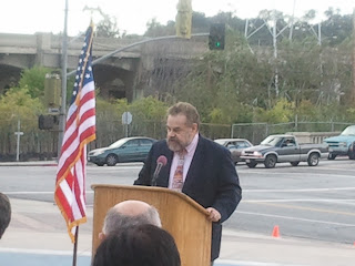
The first, the Headwaters Project, was presented by Richard Gomez (seen in the photo above) of the Los Angeles County Flood Control District, which is spearheading the effort. This $7 million riverfront project, a LA County collaboration with the Los Angeles LA River Office, the City Department of Transportation and the LA County Bicycle Coalition, includes the creation of bioswales, native plants, interpretative signage and connectivity with the LA River Bicycle Path.

This project is in a key West San Fernando Valley location near De Soto and Browns Creek Bridge, and, when completed, will serve thousands of residents within its close proximity to 3 schools, Quinby Park, Topanga Plaza and other local business districts. The project anticipates completion by May 2013. It will have no channel capacity impact.

The second approved project, sponsored by the Los Angeles River Revitalization Corporation, is located in the North Atwater Park area of the LA River and entails the building of a new 'Atwater Park Multi-Modal Crossing,' a hybrid bridge over the LA River that will allow walkers, bicyclists and equestrians to 'share the crossing' as a safe connection from Atwater to Griffith Park.

This projected $3 million project, a collaboration with Buro Happold, Fuscoe Engineering, Mia Lehrer+Associates, Gardiner+Theobald and Tetra Tech, will be a 230-280 foot long span with a 27-30 foot width. The project managers are currently evaluating arch, cable truss, and cable suspension design options.

Most importantly, the Atwater Crossing will mark the first LA River project that will totally privately funded by an enthusiastic donor, according to LA River Revitalization Corporation Board Chair Daniel Tellalian.

Other announcements included:

.April 30th is the Annual Mayor's Day of Service and this year will focus exclusively on Los Angeles River clean-up projects and events, in cooperation with Friends of the LA River and the Los Angeles River Office.  Attendees were encouraged to 'get out the volunteers' on April 30th, since the Cities of Los Angeles and Chicago are having a friendly competition to see who can get more volunteers involved in their respective river projects.

.Mark Pestrella, Los Angeles County Assistant Director of Public Works, noted that the Lake Alameda Greenway Project at Victory and Alameda in Burbank had just had its Groundbreaking. He also stated that there will be a June dedication for the retrofitting of Big Tujunga Dam, which will increase capacity by 4500 acre feet of stormwater capture. Finally, 40 acres in the Sun Valley Watershed have been purchased by the County to design and create an upper area wetland project in Sun Valley Park with LA City and LADWP partners.

The LA Zoo Parking Lot Stormwater demonstration project will be dedicated on April 7th at 9:30am.

The City of Glendale Riverwalk groundbreaking is scheduled for April 14th at noon.

The annual Los Angeles County Bicycle Coalition LA River Bike Ride will be held this year on June 5th.

The next meeting of the River Cooperation Committee is scheduled for July 5, 2011.

Tuesday, April 5, 2011

South Pasadena Nature Park vs Golf Course Woes: More Complicated than it Looks

This Wednesday night, the South Pasadena City Council will be considering a proposal to move the Arroyo Seco Golf Course inland and extend its current footprint southward into open space that is currently part of the South Pasadena Nature Park.

Nature Park lovers and local environmentals are understandably upset about this proposal but, as usual, there is more to the problem than casually meets the eye.

The Arroyo Seco Golf Course is a publically owned Par 3 course that was established in 1955. Its location next to the beautiful Arroyo Seco stream, its charming mid-century club house/grill, and its reasonable greens fees has made it popular over the years with golfers of all ages and skill levels. In fact, ASGC has been rated as one of the Top 10 Los Angeles Area Par 3 Golf Courses by Hemispheres Magazine. As a golfer, I agree with their assessment that the only thing it lacks are grass tee boxes.

For years, the City of South Pasadena has contracted out golf course and tennis facility management to a vendor who runs the operations. That contract is now out to bid...and here's where the trouble begins.

One potential operator has requested that the City allow them to extend the current driving range about 100 yards or so southward into currently natural land of grasses and Sycamore trees since, according to reliable sources, men now like to drive 200 yards or more off the driving range tee and the current range is too short for that.

Friends of the South Pasadena Nature Park are understandably alarmed with this encroachment into current open space with the seemingly sole goal of revenue enhancement for the City and course operator.

But here's where things get a little complicated. For a number of years, several arroyo lovers and City officials have been looking for ways to extend a riverfront greenway along the Arroyo Seco through South Pasadena to allow walkers, bicyclists and equestrians connectivity northward with trails along the river in Pasadena. Discussions called for a 20-foot setback from where the driving range currently is aligned next to the stream, which was deemed possible to achieve at the time the Golf Course management contract came up for renewal, which is now.

While Wednesday night's proposal does not directly tie the driving range relocation inland and extension southward with the establishment of the green trailway next to the Arroyo Seco, the greenway was definitely the impetus for initial discussions for moving the driving range inland to accommodate a trail linkage.

Now, a good intention is becoming linked with potential loss of open space.

But here's the curious part. The Arroyo Seco Golf Course is only 2,185 yards long. It also has a 9 hole mini-course (think putt-putt) that has attracted families for years. I play this course because I don't have a long drive swing, I can score well on this Par 54 course, and I love the natural brook that flows through the course.  In addition, I can enjoy vistas to the York Blvd. bridge to the south and the San Gabriel Mountains to the north.  Best of all, the wideness of the river channel contour next to the Golf Course makes it imminently feasible for major restoration, including access to the grassy island on the west bank.

Instead of lengthening the driving range, the South Pasadena City Council should be more concerned about preserving this historic gem, designed by William H. Johnson, American Society of Golf Course Architects. Johnson, who died in 1979, designed several golf courses in Southern California including De Bell Golf Course in Burbank, Alondra Park Golf Course in Lawndale, and South Gate Municipal Golf Course.

Rather than taking up more land for questionable revenue (a large bucket of balls costs $8 for the driving range), South Pasadena would be better served  by contracting with an operator who 'gets' how to successfully market this special facility, seek Historic Landmark Status for the course, and lose 20 feet of the driving range so the Arroyo Seco Greenway can be completed.

Let the 'long drivers' go hit balls on full size course driving ranges. Let me still have a place where I can 'birdie' a hole. Let the community enjoy a round of golf in one of Southern California's prettiest settings.

Sunday, April 3, 2011

Arroyo Seco - Los Angeles River Confluence Plaza Opens to the Public

There's a new place where you can play in the water in Los Angeles. It's located right near the Arroyo Seco-Los Angeles River Confluence in Cypress Park at the intersection of San Fernando Road and Figueroa Street.

Last Wednesday, about 100 governmental, civic, and environmental leaders attended the official dedication of the Confluence Plaza, the first phase of a planned Confluence Park where the history of Los Angeles really began: the natural intersection of the Arroyo Seco with the Los Angeles River, close to where Avenue 19 and southbound Interstate 5 now meet.


Confluence Plaza, a project of the Mountains Recreation and Conservation Authority (MRCA), was funded by California State Parks (Proposition 12), EEM Caltrans, and the Santa Monica Mountains Conservancy (Proposition 84), to serve more than 1,000,000 Angelenos in the adjacent Northeast Los Angeles communities of Cypress Park, Lincoln Heights, Mount Washington, Elysian Valley and Silver Lake as well as commuters heading to work in downtown Los Angeles.


The Dedication Ceremony was hosted by Santa Monica Mountains Conservancy
Executive Director Joe Edmiston (seen on the left here), who spoke briefly about the work of SMMC and the MRCA is providing parks and open space within Los Angeles' dense urban neighborhoods.

He also introduced comments by a number of civic leaders, including Los Angeles City Councilmember Ed Reyes (seen below), who has championed the revitalization of the Los Angeles River for many years. Lewis MacAdams, Co-Founder of Friends of the Los Angeles River, read his latest poem with river imagery, 'To Lesley,' to the gathered crowd.

The Confluence Plaza is located on one of
Los Angeles' most historical sites: the Juan Baustista De Anza National Historic Trail, which marks the Anza expedition of 1776 which led to the founding of the settlement that would later become El Pueblo de la Reina de Los Angeles.

The open air plaza was designed by Mia Lehrer + Associates and  features an interactive water feature designed by WET Designs, whose creations include water elements at the Los Angeles County Music Center, Universal CityWalk and the Bellagio Hotel in Las Vegas.

The plaza's water feature is designed to attract neighborhood children and residents while offering them the opportunity to learn more about Los Angeles history. Its location not far from the completed and proposed sections of the Los Angeles River Bicycle Path should make it a popular stopping point for cyclists, too.


Spearheading this innovative project was Barbara Romero, Chief of Urban Projects & Watershed Planning for MRCA, seen here center right with Los Angeles River Women Leaders, including CD 1 Environmental Deputy Jill Sourial, LA Chief Deputy City Engineer Deborah Weintraub, Project Architect Mia Lehrer, and Los Angeles City River Office Project Director Dr. Carol Armstrong.

Arroyo Lover's tips for visiting the Plaza, which is free and open to the public: Park in the south section of the Home Depot Parking Lot. The fountains are timed to 'splash' for 10 minutes every hour on the hour from 8 am to 8pm. And don't forget to be Riverly!